 |
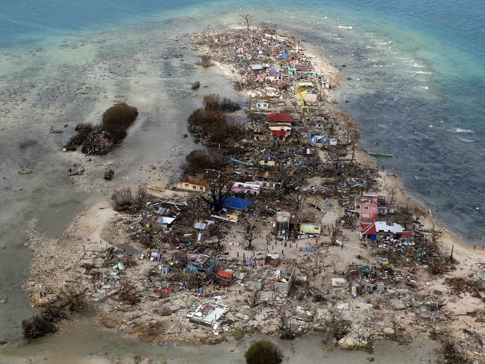
| Typoon Haiyan |
 |
| Survivor Typhoon Haiyan |
2. The 1976 Moro Gulf earthquake and tsunami took place on August 16, 1976, at 16:11 UTC (on August 17, 1976, at 00:11 local time),near the islands of Mindanao and Sulu, in the Philippines. Its magnitude was calculated as being as high as 8.0 on the moment magnitude scale. The epicenter was in the Celebes Sea between the islands of Mindanao and Borneo. The Pacific Tsunami Warning Center's preliminary magnitude was given as 8.0 on the Richter scale and as 7.9 by other sources. There were many aftershocks following the main earthquake. A major aftershock on August 17 (local date) had a magnitude of 6.8. It was followed by at least fifteen smaller aftershocks.
The initial earthquake was widespread and was felt as far as the central Philippine islands of the Visayas. A massive tsunami devastated 700 kilometers of coastline bordering the Moro Gulf in the North Celebes Sea, resulting in destruction and death in the coastal communities of the Sulu Archipelago and southern Mindanao, including Zamboanga City and Pagadian City. At least 5000 people died during the earthquake and tsunami, with thousands more remaining missing. Some reports say that as many as 8,000 people lost their lives in total, with ninety percent of all deaths the result of the following tsunami.
Initially over 8,000 people were officially counted as killed or missing, 10,000 injured, and 90,000 homeless, making the 1976 Moro Earthquake and Tsunami one of the most devastating disasters in the history of the Philippine Islands.[5] After the initial earthquake the people were unaware of the need to move to higher ground; when the tsunami hit it sucked most of the victims out to sea. Based on the investigation on the affected region it was confirmed that the waves reached up to 4 to 5 metres (13 to 16 ft) when they hit the areas. There were reports of weak tsunami activity as far as Japan, as well as Indonesian Hydrographic Office reports of unusual wave activity affecting the islands of Sulawesi (Celebes Island) and Borneo.
In Zamboanga City, 14 buildings were partially damaged. Zamboanga City was spared from serious damage of the tsunami triggered by this earthquake because the Basilan Island and the Santa Cruz Islands served as a buffer and deflected waves.
3. Tropical Storm Thelma, known in the Philippines as Tropical Storm Uring, was one of the deadliest tropical cyclones in Philippine history, killing at least 5,081 people. Forming out of a tropical disturbance on November 1 several hundred kilometers north-northeast of Palau, the depression that would become Thelma tracked generally westward. After turning southwestward in response to a cold front, the system intensified into a tropical storm on November 4, 1991 as it approached the Philippines.
Tropical Storm Thelma struck the Philippines just five months after the Ultra-Plinian eruption of Mount Pinatubo. The eruption resulted in the deaths of roughly 800 people and left nearly 1 million homeless.
4. Typhoon Bopha, known in the Philippines as Typhoon Pablo, was the strongest tropical cyclone to ever hit the southern Philippine island of Mindanao, making landfall as a Category 5 super typhoon with winds of 175 mph (280 km/h). Bopha originated unusually close to the equator, becoming the second-most southerly Category 5 super typhoon, reaching a minimum latitude of 7.4°N on December 3, 2012.
The death toll reached 1,067 people, with most on the southern island of Mindanao, where floods and landslides caused major damage on December 4. A total of 834 people remain missing, about half of them are fishermen.
5. The Luzon earthquake occurred on Monday, July 16, 1990, at 4:26 PM local time in the Philippines. The densely populated island of Luzon was struck by an earthquake with a 7.8 Ms (surface-wave magnitude). The earthquake produced a 125 km-long ground rupture that stretched from Dingalan, Aurora to Cuyapo, Nueva Ecija as a result of strike-slip movements along the Philippine Fault and the Digdig Fault within the Philippine Fault System. The earthquake epicenter was placed at 15° 42' N and 121° 7' E near the town of Rizal, Nueva Ecija, northeast of Cabanatuan City.[1] An estimated 1,621 people were killed in the earthquake, most of the fatalities located in Central Luzon and the Cordillera region.
The popular tourist destination of Baguio City, situated over 5000 feet above sea level, was among the areas hardest hit by the Luzon earthquake. The earthquake caused 28 collapsed buildings, including hotels, factories, government and university buildings, as well as many private homes and establishments. One of the more prominent buildings destroyed was the Hyatt Terraces Hotel where at least eighty hotel employees and guests were killed. However, three hotel employees were pulled out alive after having been buried under the rubble for nearly two weeks, and after international rescue teams had abandoned the site convinced there were no more survivors.
6. Typhoon Ike, known in the Philippines as Typhoon Nitang, was the deadliest typhoon of the 1984 Pacific typhoon season and crossed the Philippines in September. This tropical cyclone formed on August 27 in the Philippine Sea, and strengthened as it moved westward into the southern Philippines, becoming a typhoon on August 31. Typhoon Ike caused extreme wind and flooding damage when it crossed the Philippines, resulting in 1492 fatalities, one of the Philippines' worst natural disaster in modern times, and its worst typhoon since Amy struck the archipelago in 1951.
7. Taal Volcano is a complex volcano located on the island of Luzon in the Philippines. It is the second most active volcano in the Philippines with 33 historical eruptions. One of the more devastating eruptions occurred in January, 1911.The eruption claimed a reported 1,335 lives and injured 199; although it is known that more perished than the official records show. The seven barangays that existed on the island previous to the eruption were completely wiped out. Post mortem examination of the victims seemed to show that practically all had died of scalding by hot steam or hot mud, or both. The devastating effects of the blast reached the west shore of the lake where a number of villages were also destroyed. Cattle to the number of 702 were killed and 543 nipa houses destroyed. Crops suffered from the deposit of ashes that fell to a depth of almost half an inch in places near the shore of the lake.
8. Mayon Volcano, also known as Mount Mayon, is an active volcano in the province of Albay, on the island of Luzon in the Philippines. Renowned as the "perfect cone" because of its almost symmetric conical shape, the mountain was declared a national park and a protected landscape on July 20, 1938, the first in the country. It was reclassified a Natural Park and renamed Mayon Volcano Natural Park in the year 2000.
Local Philippine folklore refers to the volcano as Bulkang Mayon (Bikol: "Mayon volcano"), after the legendary heroine Daragang Magayon (Bikol: "Beautiful Lady").

The most destructive eruption of Mayon occurred on February 1, 1814. Lava flowed but not as much compared to the 1766 eruption; Instead, the volcano was belching dark ash and eventually bombarded the town of Cagsawa with tephra that buried it. Trees were burned; rivers were certainly damaged. Proximate areas were also devastated by the eruption, with ash accumulating to 9 m (30 ft) in depth. In Albay, a total of 2,200 locals perished in what is considered to be the most lethal eruption in Mayon's history; estimates by PHIVOLCS list the casualties at about 1,200, however. The eruption is believed to have contributed to the accumulation of atmospheric ash, capped by the catastrophic eruption of Mount Tambora in 1815, that led to the Year Without a Summer in 1816.
9. A massive rock slide-debris avalanche occurred on February 17, 2006 in the Philippine province of Southern Leyte that caused widespread damage and loss of life. The deadly landslide (debris flow) followed a ten-day period of heavy rains and a minor earthquake (magnitude 2.6 on the Richter scale). The official death toll was 1,126.
10. Severe Tropical Storm Washi, known in the Philippines as Tropical Storm Sendong, was a late-season tropical cyclone that caused catastrophic damage in the Philippines in late 2011. Washi, which means Aquila in Japanese, made landfall over Mindanao, a major island in the Philippines, on December 16. Washi weakened slightly after passing Mindanao, but regained strength in the Sulu Sea, and made landfall again over Palawan on December 17. In the Philippines, catastrophic flash flooding triggered by Washi resulted in at least 1,268 fatalities.
Source: Wikipedia
Photo credit to the owners.
No comments:
Post a Comment